Taipei, July 5 — Typhoon Danas has intensified into a light Typhoon No. 4 as of 2 a.m. on Friday, July 5, prompting the Central Weather Administration (CWA) to issue a sea typhoon warning at 8:30 a.m. today. If the typhoon maintains its current trajectory, a land typhoon warning is expected to be issued at 8:30 p.m. tonight.
According to the CWA, Typhoon Danas is forecast to be closest to Taiwan between Sunday (July 6) and Monday (July 7). The storm’s outer circulation is expected to bring heavy rainfall and strong winds across the island, particularly affecting the central, southern, and eastern regions.
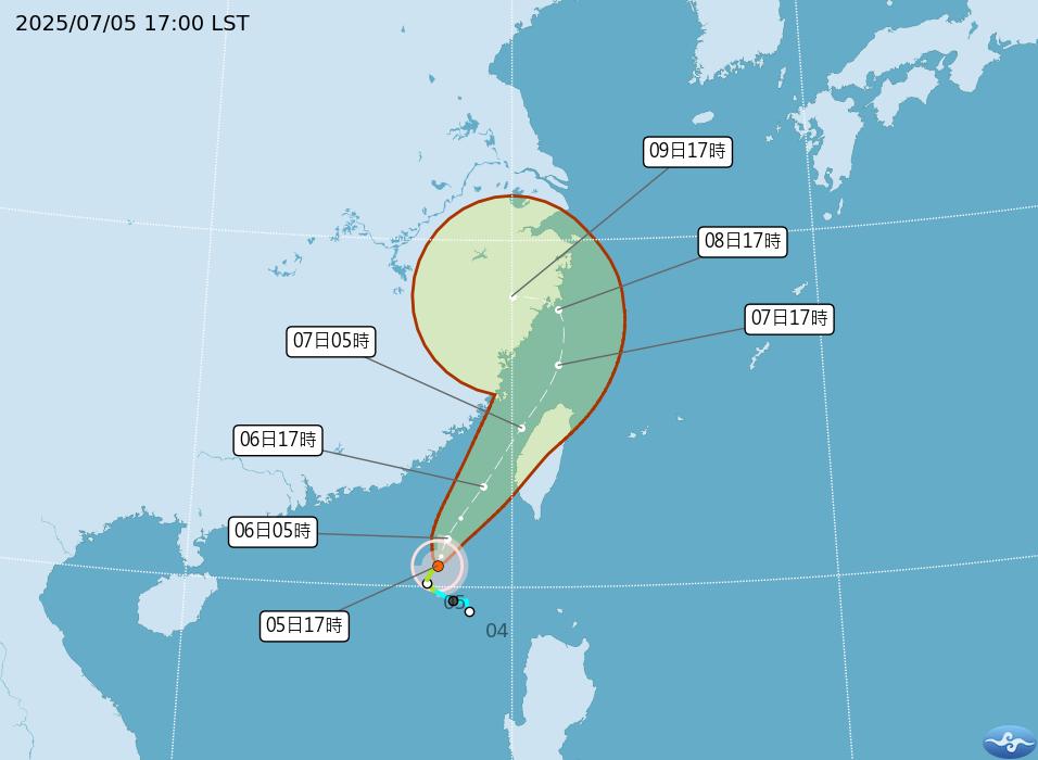
As of 5 p.m. on July 5, Danas was located at 20.6°N latitude and 117.7°E longitude, approximately 360 kilometers southwest of Eluanbi. The typhoon is moving in a north-northeast to northeast direction at a speed of 10 to 20 kilometers per hour. Its central pressure is recorded at 992 hPa, with maximum sustained winds near the center reaching 23 meters per second (about 83 km/h), equivalent to a Force 9 wind. Maximum gusts are clocked at 30 meters per second (approximately 108 km/h), equal to a Force 11 wind.
Rainfall and Wind Alerts
The outer bands of Typhoon Danas are already influencing Taiwan’s weather. Short-term heavy rainfall is expected, with Nantou, Yunlin, and Chiayi counties facing the possibility of heavy to torrential rain. Localized downpours may also occur in areas south of Miaoli, the Taitung region (including Lanyu and Green Island), Hengchun Peninsula, and Hualien’s mountainous zones.
A land-based strong wind advisory (yellow alert) has been issued for New Taipei, Tainan, Kaohsiung, Pingtung, Yilan, Hualien, Taitung, and Penghu. These areas may experience average winds of Level 6 and gusts exceeding Level 8 today. Residents are urged to be cautious of falling debris and power outages.
Sea Warning Details
The sea typhoon warning advises all vessels operating in the waters near Dongsha Island, the Bashi Channel, and the Taiwan Strait to remain vigilant. Wind and wave activity is expected to intensify, particularly in the Bashi Channel, southern Taiwan Strait, and waters surrounding Penghu.
Long ocean swells are also likely along the southern and southeastern coastlines of Taiwan, including Lanyu, Green Island, and the Hengchun Peninsula.
High Temperature Alerts
In addition to storm threats, elevated temperatures are expected in parts of northern Taiwan. Taipei, New Taipei, Taoyuan, and Kinmen are under an orange alert for temperatures reaching up to 36°C. Changhua is under a yellow alert. The public is advised to stay hydrated and avoid prolonged outdoor activities.
Suspension of Work and Classes
As of now, there has been no official announcement regarding the suspension of work or classes. However, due to expected severe weather on Sunday, particularly in southern and southeastern regions, schools, government agencies, and companies such as Taipower are urged to begin evaluating precautionary measures.
Updates regarding class and work suspensions will be posted as soon as announcements are made by local governments.
Stay Informed
The Central Weather Administration is continuously monitoring the situation. The public is encouraged to follow official updates and prepare emergency kits in anticipation of possible disruptions. For the latest storm path updates, warnings, and safety tips, stay tuned to official bulletins and news outlets such as TVBS News Network.