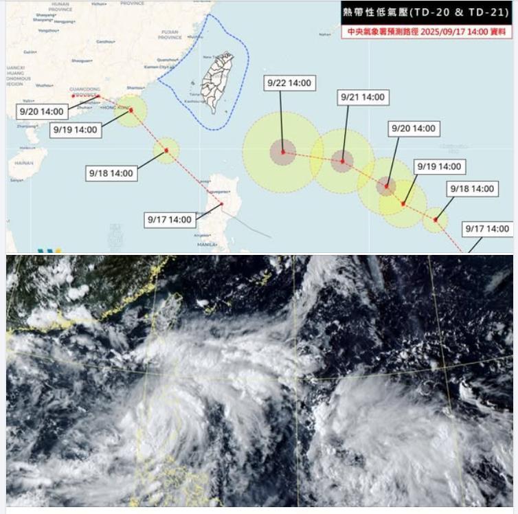
September 17, 2025 — Weather experts are closely monitoring two tropical depressions currently active in the northwest Pacific—designated TD20 and TD21—which are both expected to intensify into typhoons by tomorrow, September 18.
According to meteorologist Wu Shengyu, senior consultant at a private weather risk firm, forecast data and satellite imagery suggest that TD20 will strengthen in the South China Sea while TD21 will intensify east of the Philippines. Once upgraded, these systems will be identified as Typhoon No. 17 and Typhoon No. 18, depending on the classification by the Japan Meteorological Agency.
Wu explained that although two typhoons may exist at the same time, this does not necessarily mean a “Fujiwhara effect” will occur—a phenomenon in which typhoons rotate around each other and alter their paths. At present, he said, the two weather systems are being steered by different air currents and remain far enough apart to follow separate tracks.
The forecast path shows TD20 moving closer to Hong Kong, while TD21 is expected to affect Taiwan beginning early next week. Current projections indicate TD21 will approach the southeastern waters of Taiwan and the eastern part of the Bashi Channel on Monday, September 22. By Tuesday, September 23, it will pass south of Hengchun and be at its closest point to Taiwan before gradually moving away by Wednesday, September 24. The system may later track toward Hong Kong, Macau, or nearby waters.
Wu emphasized that TD21 poses the greater concern for Taiwan, particularly in Hualien, Taitung, the Hengchun Peninsula, Kaohsiung, and Pingtung. Even if these areas do not experience a direct landfall, the storm’s wide circulation is expected to bring strong winds and heavy rain across much of the island.
He added that the exact impact will become clearer in the next two to three days as the storm path develops. A slight northward or southward shift in the trajectory could significantly change the severity of weather conditions across different regions.