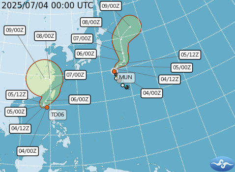
TAIPEI, July 4 — A tropical depression near the northwestern coast of the Philippines is gaining strength and is likely to develop into Tropical Storm Danas by early Saturday, making it the fourth named storm of the season, the Central Weather Administration (CWA) announced Friday.
As of 8 a.m., the weather system was located around 370 kilometers southwest of Cape Eluanbi, the southernmost tip of Taiwan. The system has become more organized and is currently moving slowly in an east-northeast direction toward the Taiwan Strait, according to CWA forecaster Lee Meng-hsuan (李孟軒).
If the system strengthens further, the CWA may issue a sea warning as early as Saturday morning.
Storm Likely to Pass Closest to Taiwan Late Sunday
Lee noted that the storm is expected to change course later on Saturday, turning north or northeast, and will likely approach Taiwan most closely between Sunday and early Monday. It is forecasted to move across or near the Taiwan Strait, increasing the risk of hazardous weather conditions.
“Heavy rain is expected on Sunday,” Lee said, especially in southern and southeastern mountainous areas, while other regions may see scattered localized showers. However, he also emphasized that the storm’s track remains uncertain and should be monitored closely in the coming days.
Experts Urge Public to Stay Alert
Independent meteorologist Wu Der-rong (吳德榮) echoed the CWA’s warning, stating that the storm’s most significant impact on Taiwan will likely occur between Sunday and early Monday.
“The threat should not be underestimated,” Wu said, urging the public to stay informed and prepared as the system continues to evolve.
Authorities are advising residents, particularly in low-lying and mountainous areas, to be on alert for potential flooding, landslides, and strong winds. Fishermen and those at sea are also encouraged to take extra precautions as the storm intensifies.


