September 25, 2025 — Manila
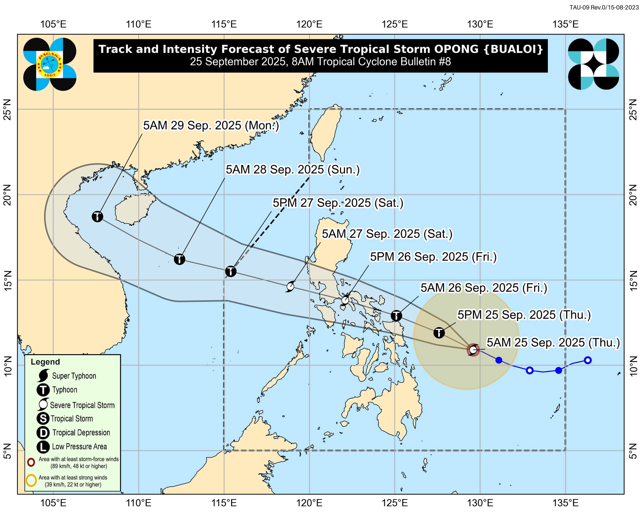
Severe Tropical Storm Opong (international name: Bualoi) continues to maintain its strength while moving closer to the Eastern Visayas and Bicol Region, according to the 8:00 AM bulletin issued by PAGASA. The storm is expected to intensify further and may reach typhoon category before making landfall.
Location and Strength
As of 7:00 AM, the storm’s center was located about 365 km east of Guiuan, Eastern Samar. Opong packs maximum sustained winds of 110 km/h, gusts reaching up to 135 km/h, and a central pressure of 980 hPa. It is currently moving west-northwestward at 20 km/h.
Strong to storm-force winds extend outward up to 450 km from the center, affecting large areas of Luzon and Visayas.
Wind Signals in Effect
-
Signal No. 2 (Gale-force winds) is raised over parts of Bicol Region, Northern Samar, central and northern Eastern Samar, northern Samar Province, and northern Biliran. Winds in these areas may reach 62–88 km/h, posing minor to moderate threats to life and property.
-
Signal No. 1 (Strong winds) covers Metro Manila, most of Luzon, much of the Visayas, and parts of Mindanao including Dinagat and Siargao Islands. Winds here may reach 39–61 km/h, bringing minimal to minor threats.
PAGASA warns that wind signals may be raised higher, with Signal No. 4 possible as the storm intensifies.
Rainfall, Winds, and Storm Surge
The combined effect of Opong and the Southwest Monsoon is expected to bring heavy rains, gale-force winds, and storm surges:
-
Storm surge heights of 1–3 meters may affect low-lying coastal areas in Bicol, Metro Manila, CALABARZON, MIMAROPA, and Eastern Visayas within 36 hours.
-
Sea conditions remain dangerous, with waves up to 11 meters in parts of Catanduanes, Albay, Sorsogon, and Northern Samar. All types of vessels are advised to stay in port until conditions improve.
Track and Outlook
On its current track, Opong may either pass close to Northern Samar or make landfall in the Bicol Region by Friday morning or early afternoon (September 26). It is forecast to cross Southern Luzon before exiting into the West Philippine Sea by late Saturday (September 27).
The storm is expected to intensify further before landfall, possibly becoming a typhoon, then weaken slightly while traversing Luzon. Once it moves over open waters, re-intensification is highly likely.
Advisory
PAGASA urged residents in areas under wind signals and flood- or landslide-prone communities to prepare for possible evacuations. Local disaster risk reduction offices have also been advised to implement precautionary measures.
The next official tropical cyclone bulletin will be released at 11:00 AM today.