August 22, 2025 – 11:00 AM Update
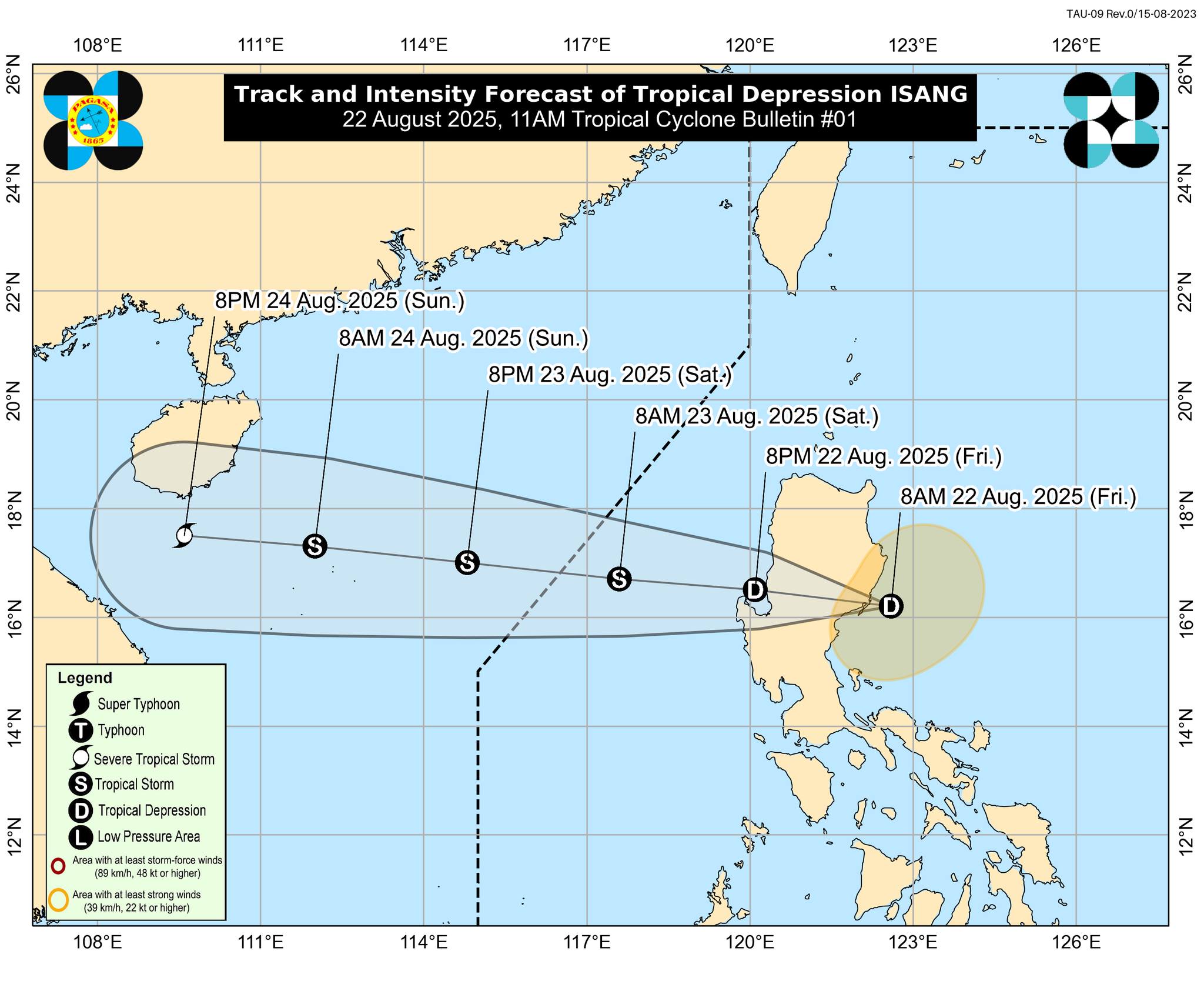
The Philippine Atmospheric, Geophysical and Astronomical Services Administration (PAGASA) confirmed that the low-pressure area east of Aurora has intensified into Tropical Depression “Isang” and made landfall in Casiguran, Aurora this morning.
Location and Strength
As of 10:00 AM, the center of “Isang” was located near Casiguran, Aurora (16.3°N, 122.1°E). It is moving west at 15 km/h, carrying maximum sustained winds of 55 km/h and gusts reaching up to 90 km/h. The tropical depression’s strong winds extend outward up to 200 km from its center.
Areas Under Tropical Cyclone Wind Signal No. 1
Residents in several Luzon provinces are advised to prepare for strong winds with minimal to minor impacts on life and property. Areas currently under Signal No. 1 include:
-
Batanes, Cagayan, Isabela, Quirino, Nueva Vizcaya, Apayao, Kalinga, Abra, Mountain Province, Ifugao, Benguet, Ilocos Norte, Ilocos Sur, La Union, Pangasinan.
-
Northern and central Aurora (Casiguran, Dinalungan, Dilasag, Baler, Maria Aurora, Dipaculao, San Luis).
-
Northern Nueva Ecija (Lupao, Carranglan, Pantabangan, San Jose City).
Rainfall and Wind Hazards
Heavy rainfall is expected over parts of Luzon and Visayas as “Isang” interacts with the Southwest Monsoon. Gusty conditions will be felt in Aurora, Zambales, Bataan, Metro Manila, CALABARZON, MIMAROPA, Bicol, Western and Central Visayas, Dinagat Islands, Surigao del Norte, and Camiguin today. By Saturday, strong winds may affect Batanes, Cagayan, Ilocos Region, CAR, and parts of Central and Southern Luzon.
Coastal and Sea Conditions
While no gale warning is in effect, rough seas reaching up to 3.0 meters are expected along the coasts of Batanes and Cagayan. Moderate seas will prevail in the seaboards of Isabela, Ilocos provinces, Aurora, Zambales, Bataan, and Lubang Island. Small boats and inexperienced mariners are strongly discouraged from venturing out.
Forecast Track and Development
“Isang” is expected to continue moving west, crossing Northern Luzon within the next 12 hours before emerging over the West Philippine Sea tonight. PAGASA projects that it could strengthen into a tropical storm by Saturday morning and potentially reach severe tropical storm status while approaching the waters south of Hainan, China.
Authorities urge residents and local disaster risk reduction councils to remain vigilant, especially in flood- and landslide-prone areas. The next advisory will be issued at 2:00 PM today.