Issued at 2:00 AM, July 18, 2025
Calayan, Cagayan — Tropical Storm Crising (international name: Wipha) has slightly intensified as it continues its path along the coastal waters of Calayan in Cagayan province, according to the latest bulletin from PAGASA.
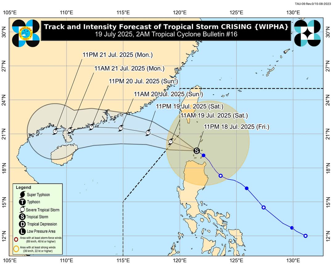
As of 1:00 AM, the storm’s center was located over the waters near Calayan, Cagayan, at coordinates 19.6°N, 121.3°E. Crising carries maximum sustained winds of 85 km/h, gusting up to 115 km/h, with a central pressure of 985 hPa. It is moving northwest at 15 km/h.
Wind Signals Raised
Tropical Cyclone Wind Signal (TCWS) No. 2 remains in effect for several areas, including Batanes, Cagayan (including Babuyan Islands), Ilocos Norte, Apayao, northern parts of Ilocos Sur and Abra, Kalinga, and parts of northern Isabela. These areas should prepare for gale-force winds of 62–88 km/h, which may pose a moderate threat to life and property within the next 24 hours.
Signal No. 1 has been raised in parts of Quirino, Nueva Vizcaya, Mountain Province, Ifugao, Benguet, La Union, and other parts of Ilocos, Isabela, Pangasinan, Aurora, and Nueva Ecija, where strong winds of 39–61 km/h may be experienced within 36 hours. These winds may cause minor damage to structures and pose minimal to minor risks.
Rainfall and Wind Impacts
Heavy rainfall associated with both Crising and the enhanced southwest monsoon continues to affect several areas. Flooding and landslides remain possible, especially in mountainous or low-lying areas. Meanwhile, strong to gale-force winds are expected across many parts of Luzon and the Visayas, particularly in coastal and elevated areas.
Storm Surge Advisory
PAGASA warns of possible storm surges reaching 1.0 to 2.0 meters in low-lying and exposed coastal areas of Batanes, Cagayan (including Babuyan Islands), Ilocos Norte, and Ilocos Sur. These could pose risks to lives and property. Residents are advised to heed local authorities’ instructions and stay away from the coast.
Sea Travel Disruptions
A Gale Warning is in effect for the northern and eastern seaboards of Northern Luzon. Sea conditions are expected to be very rough, with waves as high as 6.0 meters in areas around Batanes and the Babuyan Islands. In nearby provinces such as Ilocos Norte, Cagayan, and Isabela, wave heights may reach up to 4.5 meters. Small boats and motorbancas are strongly discouraged from venturing out due to dangerous sea conditions.
Elsewhere, moderate to rough seas are anticipated in the western seaboards of Luzon and various areas in the Visayas and Mindanao, affecting travel and fishing operations.
Forecast Track and Outlook
Tropical Storm Crising is projected to move west-northwestward, crossing the northern tip of Luzon within the day. It may exit the Philippine Area of Responsibility (PAR) later today and is forecast to intensify further, potentially reaching the Severe Tropical Storm category.
Public Safety Measures
Authorities urge residents and local disaster response units in affected areas to take precautionary actions, including evacuation if necessary. Communities vulnerable to landslides, flooding, storm surges, or strong winds should remain alert and follow local government advisories. Mariners, especially operators of small vessels, are advised to delay travel until conditions improve.
The next update from PAGASA will be released at 5:00 AM.
For localized updates on rainfall, thunderstorm advisories, and flood warnings, residents are encouraged to monitor bulletins from their respective PAGASA Regional Services Divisions.
Source: DOST-PAGASA