July 5, 2025 – Taiwan — Typhoon Danas, the fourth typhoon to form this year, developed at 2:00 a.m. and is currently positioned in the sea southwest of Hengchun, making it unusually close to Taiwan’s southern doorstep. According to meteorologist Wu Shengyu, senior consultant at WeatherRisk Company, the storm’s formation near the island is a cause for heightened concern.
Wu described the typhoon’s structure as “solid,” though its circulation remains relatively compact. Favorable surrounding conditions suggest that Typhoon Danas may strengthen further, potentially reaching the upper limits of a light typhoon or even edging into moderate typhoon territory as it approaches Taiwan over the next two days.
Typhoon Warnings Expected
If the storm continues on its current path, Wu predicts the Central Weather Administration (CWA) will issue a marine typhoon warning for the southern Taiwan Strait by 8:30 a.m. today, with expansions likely to follow for other coastal regions. A land typhoon warning covering central and southern Taiwan could be issued by tonight, depending on the storm’s speed and track.
Projected Path and Timeline
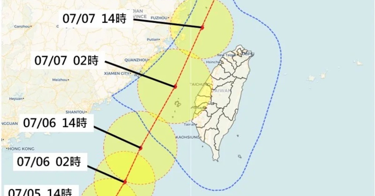
Typhoon Danas is expected to move northward slowly, then shift northeastward across the Taiwan Strait. Wu noted that while the typhoon’s speed remains slow for now, it will likely accelerate from tomorrow afternoon, with its closest approach to Taiwan occurring between tomorrow night and Monday morning. The center could pass near Penghu, although minor shifts east or west in its path remain possible. The storm’s impact on Taiwan’s western coast could intensify if it veers slightly closer.
Areas Most at Risk
The storm circle is projected to sweep across Taiwan’s western half, bringing intense wind and rain from south to north. Wu emphasized that Penghu, Kinmen, Matsu, the Hengchun Peninsula, and coastal areas from Hsinchu to Tainan should prepare for strong gusts and hazardous conditions, particularly on the east side of the typhoon, where winds are typically stronger.
From tomorrow evening to Monday morning, residents across Taiwan can expect the most severe weather, including widespread rainfall and potentially damaging winds. While northern regions like Hsinchu and Taipei may experience less precipitation, southern and central areas should be alert for heavy rain and flooding.
Short-Term Forecast and Heat Advisory
Today, Taiwan remains under the influence of southeasterly winds from the outer edge of the typhoon, which are expected to bring scattered showers in Hualien, Taitung, and the Hengchun Peninsula. In the western regions, afternoon thunderstorms could trigger localized heavy rainfall. High temperatures persist, ranging from 32–34°C in the east and 34–36°C or higher in the west, making today another scorching day.
Looking Ahead: Beyond the Typhoon
Wu forecasted that Typhoon Danas will begin to move away by Monday afternoon, gradually reducing wind and rain. However, southerly winds and lingering moisture could bring persistent rainfall to central and southern Taiwan through Monday night. Once the typhoon exits by Tuesday, Taiwan may still remain under the grip of a broad low-pressure system, which could sustain unstable weather conditions, including afternoon thunderstorms and possible disturbances or new typhoon development.
Authorities urge the public to remain vigilant, avoid coastal and mountainous areas during the typhoon, and closely monitor official updates regarding warnings and potential class or work suspensions.