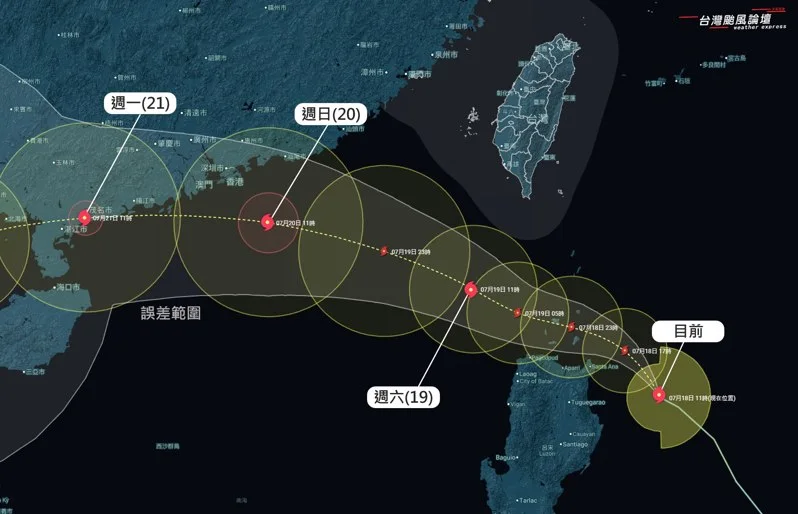
The Central Weather Bureau has issued a sea typhoon warning as Typhoon Wipha continues to strengthen and move northwest. According to updates from the “Taiwan Typhoon Forum | Weather Emergency” page, Wipha is being steered by the Pacific high pressure system and is expected to pass through the Bashi Channel on Saturday, skimming the waters south of Hengchun.
By Sunday, Wipha is forecast to pass south of Hong Kong and Macau before heading toward northern Vietnam, with a low chance of directly hitting Taiwan. However, its wide storm circulation will still bring unstable weather conditions to parts of the island.
Heavy Rain and Strong Winds Expected
Due to Wipha’s monsoon low-pressure characteristics, its outer circulation covers a broad area, prompting the weather forum to warn of significant rainfall and gusty winds from Friday night through Sunday in the following regions:
-
Yilan
-
Hualien
-
Taitung
-
Southern Pingtung
-
Northern coast of Keelung
Residents in these areas should brace for continuous downpours and gusty conditions. Greater Taipei and parts of southern coastal regions may also experience intermittent strong winds due to local terrain effects.
Mild Impact on Central and Western Regions
The Central Mountain Range is expected to shield central and western Taiwan from the worst of the typhoon’s effects. According to the forum, Taipei, southern Kaohsiung, and Pingtung may see cloudy skies with isolated showers, while areas from Taoyuan to Chiayi are likely to experience afternoon rain showers.
🌀 Note: The information provided by “Taiwan Typhoon Forum | Weather Emergency” is for academic reference only. Please refer to official forecasts from the Central Weather Bureau for accurate and updated information.
Stay Alert and Be Prepared
While a direct hit is unlikely, residents—especially in eastern and southern Taiwan—are advised to stay updated on the latest bulletins and take necessary precautions to stay safe amid the storm’s outer bands.