As of 8:00 AM, July 23, 2025
MANILA, Philippines — The Philippine Atmospheric, Geophysical and Astronomical Services Administration (PAGASA) reported early Wednesday morning that two weather disturbances inside the Philippine Area of Responsibility (PAR) have intensified, while another low pressure area (LPA) is being closely monitored just outside the country’s boundary.
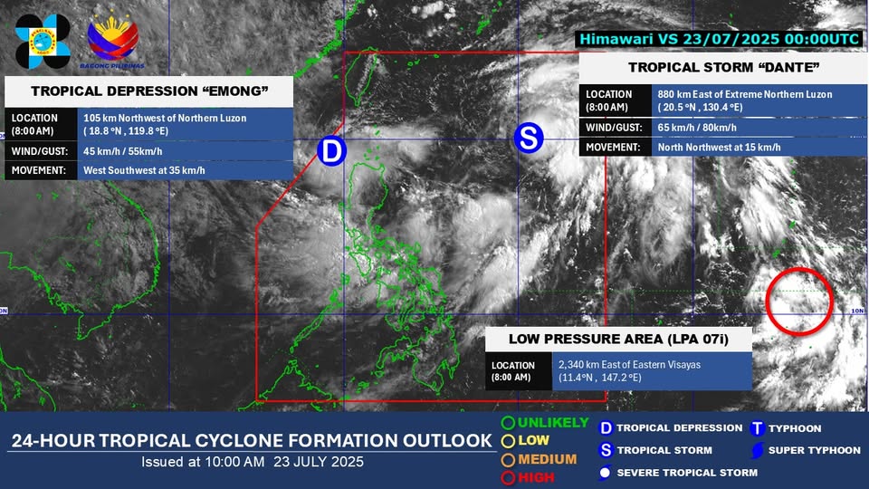
According to PAGASA’s latest tropical cyclone advisory issued at 8:00 AM, Tropical Depression “DANTE”—formerly designated as LPA 07G—has strengthened into a Tropical Storm as it moves within PAR. Forecasts are being closely observed as the system may bring rains over parts of Luzon and Visayas in the coming days.
Meanwhile, another weather system, LPA 07H, has also developed into a Tropical Depression, and has been named “EMONG”. The storm’s current location and movement are being tracked, with PAGASA expected to release storm signals if necessary.
In addition, a third weather disturbance identified as LPA 07I, which is still located outside the Philippine Area of Responsibility, has shown signs of intensification. PAGASA stated that it has a “high potential**” to develop into a tropical depression within the next 24 hours and may enter PAR soon.
PAGASA advised the public and disaster response authorities to stay alert and regularly monitor official updates, as these weather systems may bring heavy rains, gusty winds, and potential flooding, especially in low-lying and mountainous areas.
For accurate and timely weather information, follow PAGASA’s official channels and bulletins.