
Typhoon Approaches Taiwan, Bringing Heavy Rain, Strong Winds and Dangerous Waves
October 23, 2026
Taiwan is facing potentially hazardous weather as a powerful typhoon approaches, bringing heavy rainfall, strong winds, and dangerous sea conditions. The Central Weather Administration (CWA) warned that northern, northeastern, and eastern Taiwan, along with mountainous areas, could experience heavy rain and localized torrential downpours.
Forecasters also warned that the typhoon could slow down after the evening and move irregularly because of the island’s mountainous terrain. The most significant impacts were expected from that day through the early hours of the following morning.
Typhoon Moves Toward Northeastern Taiwan
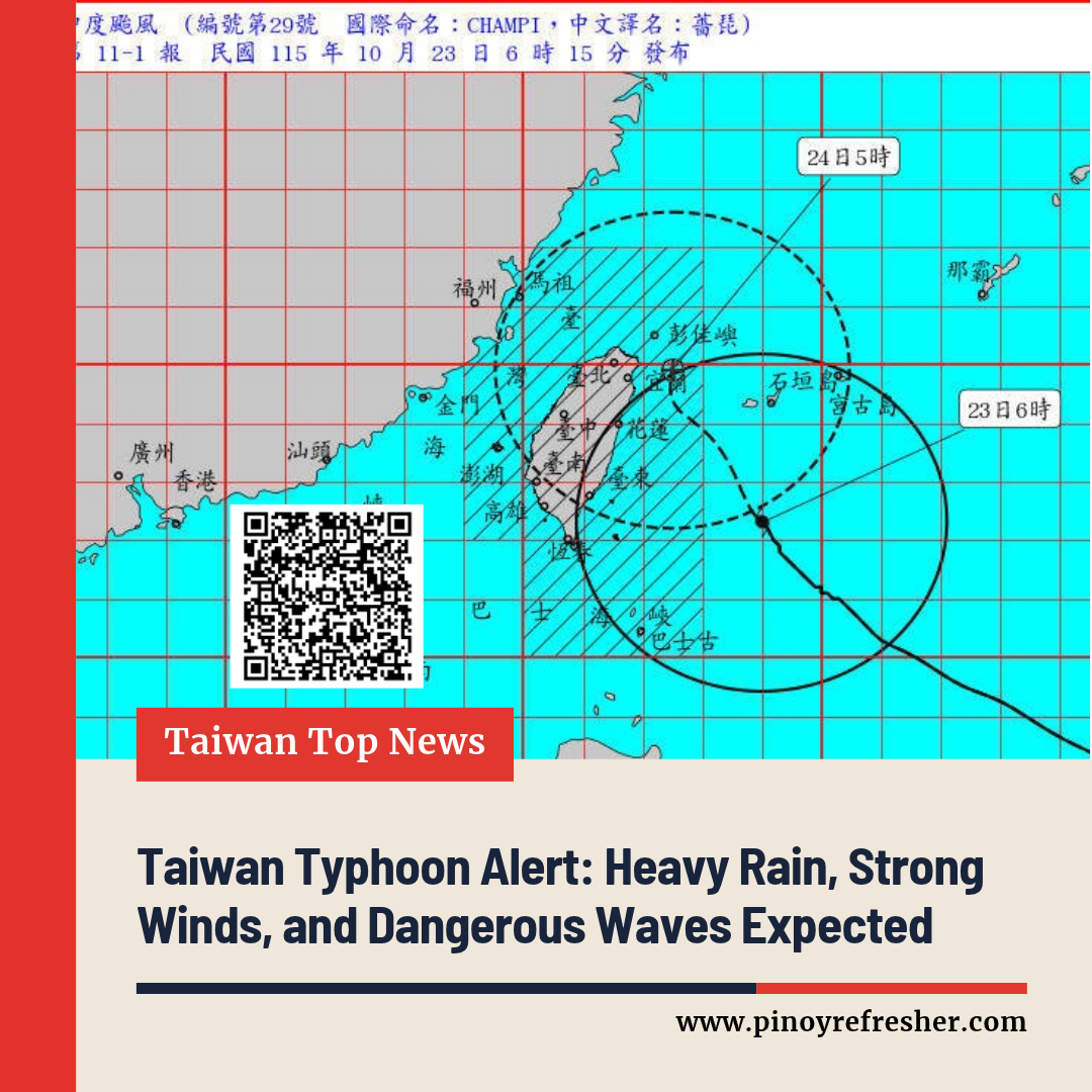
At 6 a.m., according to the weather report, the typhoon’s center was located approximately 330 kilometers east of Eluanbi, Taiwan’s southernmost point. It was moving north-northwest before turning north, with its forward speed slowing from approximately 20 kilometers per hour to 9 kilometers per hour.
The storm had a central pressure of 945 hectopascals, maximum sustained winds of 43 meters per second, and maximum gusts of 53 meters per second. These wind speeds are equivalent to approximately 155 kilometers per hour for sustained winds and 191 kilometers per hour for gusts.
The radius of force 7 winds extended approximately 320 kilometers from the center, while force 10 winds extended approximately 120 kilometers.
The typhoon’s outer wind field had reached Taiwan’s eastern land areas, while Penghu and Matsu were also under threat.
Wu Wan-hua, deputy director of the CWA Forecast Center, said the typhoon was expected to approach waters off northeastern Taiwan late that night before continuing northward into the following morning. Its slower movement and possible irregular path could prolong hazardous weather in affected areas.
Heavy Rain Expected in Northern and Eastern Taiwan
The CWA warned that heavy rain and localized torrential downpours could affect northern and northeastern Taiwan, eastern Taiwan, and mountainous areas of central Taiwan.
By 6:10 a.m., accumulated rainfall had reached approximately 142 millimeters in Yilan, 106 millimeters in Taipei, 97 millimeters in Hualien, 92 millimeters in New Taipei, and 87 millimeters in Taichung.
The agency forecast that rainfall would be most significant throughout the day and into the following morning. Northern and northeastern Taiwan were expected to experience prolonged periods of rain, while eastern Taiwan, central Taiwan, and mountainous areas in the south could receive intermittent showers.
Mountainous areas in northern and northeastern Taiwan faced a particularly high risk of torrential rainfall. Residents in affected locations were advised to remain alert to possible flooding, landslides, and other rain-related hazards.
Strong Winds Forecast Across Several Regions
The typhoon’s circulation, combined with the northeasterly monsoon, had already strengthened winds across Taiwan.
According to the report, Orchid Island had recorded gusts reaching force 15, Chenggong in Taitung had recorded force 11, and Pengjia Islet had recorded force 10.
From that morning through noon the following day, gusts reaching force 9 to 11 were forecast across coastal areas, plains, and mountainous regions.
New Taipei, Yilan, Taichung, Yunlin, and Changhua could experience gusts reaching force 12 from early morning through midday. After noon, strong winds were expected to extend southward toward coastal Chiayi, while Yilan could experience gusts reaching force 13.
Residents were advised to secure loose outdoor objects, avoid exposed areas during strong winds, and follow local authorities’ safety instructions.
Waves Could Exceed Six Meters Along the Coast
Dangerous sea conditions were also expected as the typhoon approached.
Wave heights exceeding six meters were forecast through the first half of the following day along the Keelung North Coast, Taiwan’s eastern coast, the Hengchun Peninsula, Green Island, and Orchid Island.
Other surrounding waters were expected to experience waves of approximately three to four meters, while waves near the typhoon’s center could reach around 10 meters.
Authorities urged people to avoid swimming, boating, fishing, and other activities in dangerous marine conditions. Coastal areas exposed to large waves could pose significant risks to residents and visitors.
Foehn Winds Could Push Temperatures Above 36°C
Despite the expected heavy rain and strong winds, some areas of eastern Taiwan could experience unusually high temperatures.
As the typhoon moves north, Taitung and later Hualien could experience foehn winds, which develop when air descends along the sheltered side of mountainous terrain and warms.
Local temperatures could exceed 36°C from the evening through the following day. Residents were advised to stay hydrated and take precautions against excessive heat.
Residents Urged to Monitor Weather Updates
The combination of heavy rainfall, powerful winds, dangerous waves, and possible extreme temperatures could create hazardous conditions across several parts of Taiwan.
Residents were advised to monitor the latest announcements from Taiwan’s Central Weather Administration and follow instructions issued by local authorities. Extra caution was recommended in mountainous areas, along exposed coastlines, and in locations vulnerable to flooding and landslides.